Negoreloye is an urban village in the Dzerzhinsky district. Today only about a thousand people live here. But between 1921 and 1939, about 10 thousand people a year passed through this settlement. From here began the travel of Soviet citizens to the West, and this was the first thing foreigners saw when arriving in the USSR.
In 1921, the Treaty of Riga divided Belarus in half: one side went to Bolshevik Russia, the other to Poland.
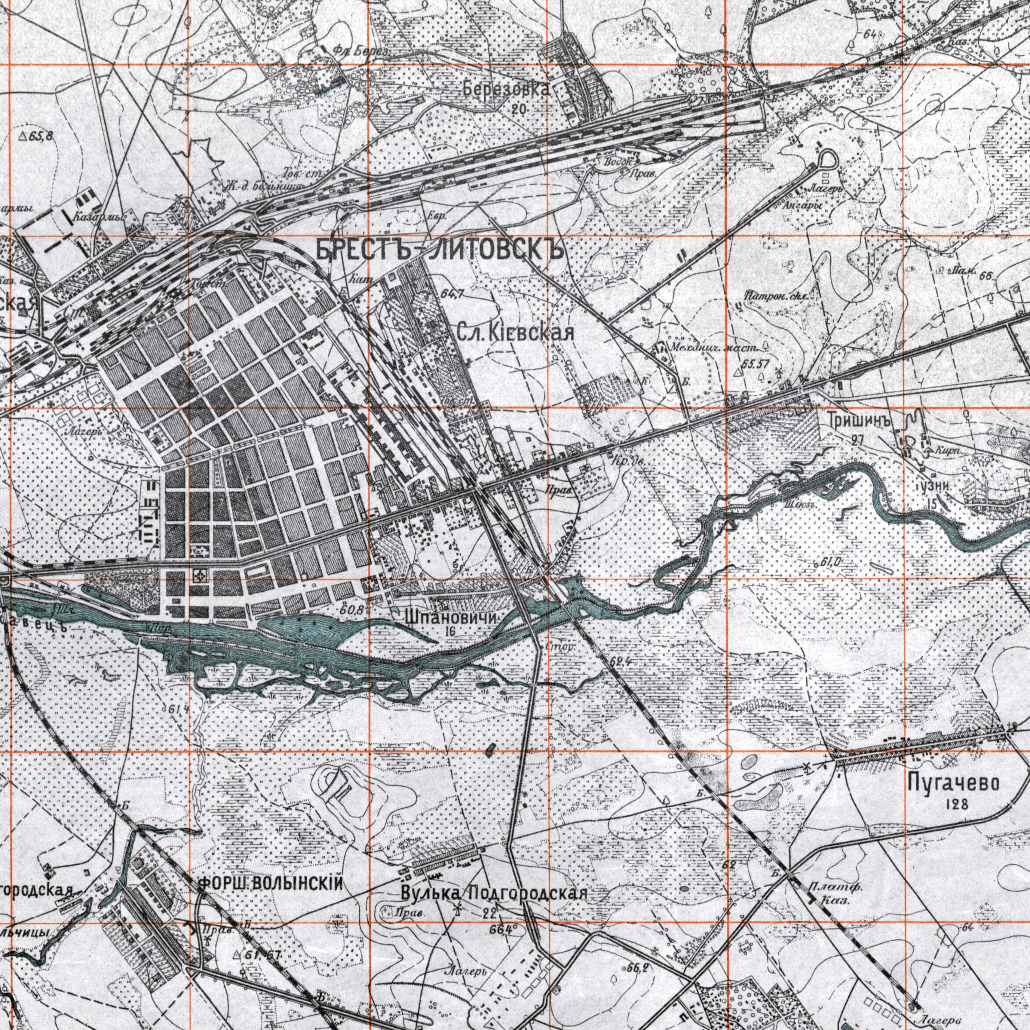
TUT.BY begins a series of materials about the border of Western Belarus and the BSSR. The first immersion into history in the faces takes place 48 kilometers southwest of Minsk. In 1871, the Moscow-Brest Railway passed through Negoreloye, and a station of the same name appeared in the village. In 1921-1939, according to the Riga Peace Treaty, the Stolbtsy and Negoreloye railway stations - extreme points on the maps of two different countries - became transit border points.
“Unburned. I first heard this word from the lips of a sleek young man sitting at the desk of the bureau of railway and steamship communications. On the walls of the bureau hung posters with alpine meadows as green as spinach, with mountain peaks turning pink in the sun, with a postcard-blue sea and mermaids who coquettishly stuck their tails out of the foaming waves and exclaimed: “Venga, a Riccione, a Riccione, lastellaverdedell'Adriatico!
And on the desk there were train schedules for almost half the world...
But the sleek young man was not impressed by either the mermaids or the Alpine meadows; he asked in a businesslike and cold manner:
- Anything?
He pushed the ticket towards me:
— There’s a transfer in Negorely! Russian roads have a wider gauge...
And he turned to the next client.
And I stood for some time with tickets in my hands and kept looking at the mermaid.
Do they exist in Negoreloye? No, you won’t find anything like that in Negorely: in Negorely there are no alpine houses or mermaids. Just a bunch of huts and sheds, a church, patches of arable land among the sprawling forest... and a few wooden barracks near the roadbed and a “buffet” in an old, disused carriage.
For the “history” of Negorely began only from the day when the Soviet-Polish commission for concluding a peace treaty drew a line on the map and decided: “The border crosses the Warsaw-Moscow railway line between the towns of Stolbtsy and Negorely, 15 kilometers west of the latter.” .
Franz-Karl Weiskopf, "Transplantation into the 21st Century"
The border that divided Belarus into two ways of life. The photo was taken from the Polish side. On the right is a Soviet border outpost. The inscription on the arch above: “Greetings to the workers of the West!”
Story
Vladimir Kharitonovich Mishuro sitting in his gazebo, on the table - his local history work about the village and two books on the history of the area. Along with the border, he discusses with us winter garlic and four varieties of chrysanthemums that grow on his site.

For many years he worked at Negorelskaya Secondary School No. 2 as a director, taught history, but retired several years ago. In Negorely this man is also known as one of the first democrats: he stood at the founding of the Belarusian Social Democratic Party. He is also the author of the unofficial coat of arms of Negorely. But most of all they love him for his subtle sense of humor.
— What is a border?- Vladimir Kharitonovich immediately asks. — The border is the escalation of psychosis: the enemy only thinks about destroying the world’s first state of workers and peasants. Therefore, old newspapers were full of various articles about how pioneers and collective farmers caught spies.
He is holding one of these pre-war newspapers - the anniversary issue of Zvyazda from 1938 with sketches about "young patriarchs" and "thieves" - in his hands. Belarusian words are written in it with “Moscow” spelling - “Communist Party (Bolshevik) of Belarus.”

— It's a pity that the museum is lost, — Vladimir Kharitonovich means the museum of history and labor glory of the Negoreloe railway station. It was opened on January 28, 1988, the exhibition was assembled together with the residents of the village. One of the sections, “The Golden Age of Negorely,” told about the station in 1921-1939, when famous people from all over the world visited it.
For a long time, the museum at the railway station housed amazing artifacts of that time. But the room suffered from constant dampness and vibrations, so about 4 years ago a small part of the museum’s exhibition was transferred to the Children’s Railway in Minsk, and part was simply burned.
Collecting the history of Negorely 1921-1939 can only be done from fragments of memories of those who saw that distant time.
Unburned
Anton Ignatievich Azarkevich, an 87-year-old veteran of the Great Patriotic War, sits on the sofa in his home in Negorely. Despite his advanced age, he lives on his own, although his children - a daughter and a son - are always nearby. It’s cold in the room, but grandpa is sitting in just his shirt—he’s comfortable.

As a 14-year-old teenager, Anton Ignatievich became a member of the Belarusian Eaglet Battalion. His whole life was connected with his native village. Here, near Negorely, on May 8, 1944, he almost died from the bullets of the White Poles.
— I lived in Soviet Belarus, 10 kilometers from the border. No one had the right to come to Negoreloye from Dzerzhinsk; a visa was needed. Even locals could not be within 5 kilometers from the border,- he says.
“They said that at night locals were forced to cover their windows.
- Well, that's not true.

— Did you have to carry your passport all the time?— we ask a lot of stupid questions, but Anton Ignatievich answers everything.
- No, the children were recorded in metrics. But for all local adults, a passport was mandatory, but of course. There were local people here, just like in ordinary villages. The unburned one was small.
After the war, I returned to Negoreloye only seven years later. I gave only nine years to my Motherland - I saw neither youth, nor youth, nor true love. But, no matter how banal it may sound, I consider myself and people like me to be sons of my Motherland. We may not be heroes, but we helped as best we could, with whatever we could - including with our lives. Now this is real life. Yes, it was a great country. I personally am very sorry that it was lost.
Vladimir Kharitonovich is democratically silent. After a pause, after thinking, Anton Ignatievich continues.

— I personally have a very positive attitude towards what we have now. Our Belarus remained united, whole, as it was. This is a great merit of our president. Why? Because he is a tough, fair, honest person. Let go of the nursery, as in Ukraine - change of power one after another. What did all this lead to? Brother kills brother, children, women, old people,— from the lips of a man who went through the war as a teenager, on horseback, with a machine gun at the ready, these words come out with pain.

- God forbid we live in an era of change,- Vladimir Kharitonovich suddenly says.
We drive along Negoreloye, Anatoly Ignatievich shows what has been preserved in the village since the first border station of the Soviet Union was here.
— How did people feel then about the fact that Belarus was divided and a border was made here?
- Calmly.
“The population treated the border the same way they treated the Soviet government. This means good. Since they decided so, it’s right,- Vladimir Kharitonovich paints a psychological picture of history.
- Certainly,- confirms Anatoly Ignatievich.
— And when the border was removed, what happened?
- The border as such was not removed - it existed until 1941. Western Belarus received us very unfriendly. Stalin in Western Belarus did what he did to the people of all of Russia: forced collectivization, private property was taken away. Western Belarus was mainly inhabited by peasants. They each have their own farm, their own land - they had to part with all this. And why were the Poles against us during the war? Because they could not forget the insult inflicted by the Soviet government. And, of course, no matter what anyone says, this was lawlessness on the part of the Soviet government in relation to the peasants - first ours, and then those of Western Belarus.

Since then, the power plant building has been preserved in Negorely. It supplied electricity to all of Negoreloye all the way to Kolosov. There were two or three German-made diesel engines standing here. After demobilization in 1951, Anton Ignatievich worked at the station. Then, like many in the village, he became a railway worker.
“Red Army soldiers on horseback race among the wet birches, then a sawmill appears with huge stacks of pine logs, and not far from it there is a power station; The upward-pointing thin tin pipe of a diesel engine spits out immaculate rings of blue smoke into the rain curtain at regular intervals. And at the engine, the first Soviet citizen out of one hundred and sixty million wipes his hat with his elbow.”
Gyula Iyesh, “Russia. 1934"
- There is no secret, now in the building, in case of war, the railway management has been organized - all kinds of equipment are located there,- says Anton Ignatievich.

The building is surrounded by a concrete fence with iron gates - no signs or ways to enter the territory. Through the cracks in the fence you can see that there is life there, and smoke is coming from the chimney: it looks like they are seriously preparing for war here. Well, or there’s nowhere else to work in Negorely.
The bathhouse has been preserved from those same times - it has not changed its purpose. Fridays are women's day, and Saturdays are men's day. Half of the bathhouse is occupied by a small store where you can buy sausage, processed cheese and booze.

Anton Ignatievich shows old preserved houses where officers lived at the customs. And now they live here, but in a different way.
But the station building was different. At that time, the station in Negorely was larger than the Minsk one.

— The old station was very beautiful, large, two-story. Foreign delegations were received here, and they ate in the restaurant here. When we went there as children, the smells were annoying,— he draws those delicious smells in the air.
The wheels were run in at the station: the border crossings had two gauges: 1520 mm - Russian, 1435 mm - European. This difference has remained to this day: if you travel from Belarus to Poland, train wheels are now changed in Brest.
From the story of Anton Azarkevich: the building on the right is intended for all citizens. To the right, diplomats were received, fed, and accommodated in a hotel. Photo: www.railwayz.info
“We have a transfer ahead, there is no further road for Polish carriages. On the other side of the platform, Russian rails begin, the distance between which - due to the foresight of the tsarist strategists - is wider than is customary in Europe.
Customs inspection is carried out in a spacious, barn-like, clean room. The floor is covered with polished parquet, the side walls form a continuous window, above the window is a portrait of Lenin; the third wall is occupied by a map of the Soviet Union, where the results of the first five-year plan are noted. The fourth wall is covered with huge paintings from floor to ceiling, giving an idea of the new Soviet style, the essence of which, as can be seen, is from a bird's eye perspective. One canvas depicts an agricultural team at work - a tractor, a thresher, a galloping herd; the other depicts the construction of the Dnieper Hydroelectric Dam. The colors of the paintings are bright, rich, reflecting the fullness of life. Along the walls, in six languages, the slogan “Workers of all countries, unite!”
In the center of the hall there is a circular control panel where passengers place their suitcases open for inspection. With professionally practiced movements, customs officers lift underwear and shoes and carefully feel each item. Foreign currency is entered in the declaration; when leaving the country, you can take out exactly that much money. The camera number is recorded in the traveler's passport. The lady next to me, returning from abroad, has her brand new Parisian toilets confiscated, accompanied by polite explanations.
Inscription on the photo: “1923. Pogranichnaya station Kolosovo MPB, where the station chief is the soldier second from the left - V. Smirnov.” From the collection of Gennady Dubatovka
There is a hotel and even a restaurant at the station."
Gyula Iyesh, “Russia. 1934"
The house in which Anton Ignatievich lived before the war is easy to find: it still stands, the very last one, at the Energetik stop. There is a well in front of the house. It is unknown who lives here now. Most likely, summer residents.

Before the war, according to Anton Ignatievich, who lived near the railway itself, there were few trains: per day one “our” passenger train went to Stolbtsy and back, and one Polish one went to Negorely and back. The same thing happened with goods. International communication was transfer.
Soviet border guards detained a border violator. Photo: www.novychas.info
“The customs inspection is over. Officials with shiny buttons and caps did their duty. In Warsaw, at the ticket office, I received a surprised refusal: a ticket to Moscow? The ticket is issued only to Stolbtsy, from Stolbtsy you take a ticket to Negorely, in Negorely you already receive a ticket to Moscow at the Russian ticket office.”
Anastasia Tsvetaeva “Memories”
—Have you never traveled across the border?
- No, my relatives didn’t go either. This was impossible because a visa was required. And they will also look at who you are, what you are like. I know that there was smuggling across the border all the time. They brought manufactured goods here (silk stockings, for example).
After a pause:
— Well, spies, of course, crossed the border.
Anton Ignatievich says that there were a lot of animals in the local forests: “the border zone, no strangers walked here: neither mushroom pickers, nor hunters, nor berry pickers.”
—What was life like on the other side of the border?
“I only know from stories that they lived there just as poorly as here.” And before the war we lived very, very poorly. Industry was very insignificant, there was agriculture - people and horses, no equipment.
— And now, what do you think, are there any differences between Western and Eastern Belarus?
- I think not. But if you cross the border - Lithuanian, Latvian - on the other side there is more culture in villages and towns. And in Western Belarus, young people are all literate. And the new generation, probably because they remain more hard-working, lives there somewhat better than us and somewhat more cultured than us.
 1949 At this time, Anton Ignatievich served in military unit 33/602, an artillery unit of special power. Some were located in the city of Krupki. 1949, city of Klintsy, Bryansk region. Anton Ignatievich's wife Maria (left) and her girlfriend - a year before the wedding. In 1946, the unit in which Anton Ignatievich served moved from Krupki to Klintsy. From part of the road went into a park forest, and in front of the forest near the houses there was a swing - on a pine tree. We met on this swing. Anton Ignatievich says: “My Manya. I walked with her for four years and didn’t demand anything - I raised her. She was small and thin. She passed away and I can’t forget her.” Photo “without preparation”: Anton Ignatievich, wife Maria, two daughters - Natasha and Valya, mother and mother-in-law. Natasha now lives near Donetsk, and Valya lives in a neighboring village. Dima’s son did not yet exist; he was born in 1956. 80th birthday of Anton Ignatievich. Standing near his house are his cousin, brother, wife Maria, in-law, workmates from Minsk and intelligence commander Nikolai Emelyanovich Budnik. From the rear in 1942, Nikolai Emelyanovich joined the partisans and there became the commander of reconnaissance, in which 14-year-old Anton Ignatievich served during the war. Then Budnik was a squadron commander when “our people came - we then caught the Germans, the Rakovites and the policemen who remained in Western Belarus and in the Pushcha - they continued to fight against the Soviet regime.” Meeting of veterans in Negorely. At the monument on the right are N. E. Budnik and A. I. Azarkevich. “There’s no one left, I’m the only one,” Anton Ignatievich comments on the photo.
 "Madhouse"
It’s cozy in the courtyard of the house where Soviet officers once lived: you want to stay here, drink tea on the street with your neighbors in the evenings, pet the cats and look at the autumn. While we are looking around, a motorcycle breaks the silence.

A woman wearing thick glasses gets out of the sidecar of a motorcycle.
- What kind of photo shoot are we having here?- the hostess begins the acquaintance.
- Do you live here? Do you know what was in this house before?
- Soldier's barracks,- says the woman.
- What a barracks,— a historical dispute ensues between the spouses. After all, it was an “officers’ house.” True, some locals no longer see the difference between the barracks and the officers’ house. The house was built in 1922, but for some reason the building’s passport says 1945, the post-war year.

Local resident Igor, a charismatic man with a large mustache, is researching the history of his village on the Internet. "Unburned '37"“,” he tells us what queries he uses in the search engine, and draws pictures on the wet sand: a two-story station, an arch, a passage of Germans. A woman approaches our already large group and, having heard the dialogues about history, sighs in disappointment:
“I thought you wanted to buy an apartment, or watch how the roof leaks.”
According to locals, the house lacks major repairs. During Javier last year, snowballs were rolling in the attic - so it was filled with snow through holes in the roof.
- Is your house called a “madhouse”?
- Our. Once upon a time, two sick people lived in our house. And you know what people are like: they took the house and called it that,— the locals know the history of the house thoroughly. They also tell how their grandmothers took them to the trains to the border to sell mushrooms and berries to earn extra money.
- We were all poor, the Poles lived better,- Igor explains this fact. — When we had a revolution, fists appeared. Who are the kulaks? Here's my car - he points to his jeep. — They would say to me: you are a fist! Everything was confiscated from the kulaks and given to the proletarians. But who are the proletarians? The proletarians are now standing near the shops - they are knocking down rubles.

“I’m dying of laughter now,” says Igor's neighbor. He interprets the story very emotionally.
Barracks
The old wooden house, which was built specifically for customs officers, now houses 12 families. According to locals, the house has long been recognized as unsafe, but is not being removed from the balance sheet, and they have little hope of moving out of these historical slums.

- Take pictures, show that it’s no longer possible to live here, it’s scary here,- a woman in a burgundy sweater tells us. Her name is Maria, she is now retired, but she used to work at a local school.
- The slightest water, a gap - there is water under the floors. If you want, dive, if you want, swim. Go to the barns - you should definitely take pictures of them. There are no such things anywhere else - you will have an exclusive,- the locals promise us.

“I look out the window of one of the village houses. Nickel-plated bed with a mountain of pillows. The bed linen is dazzling white. A large lamp hangs from the ceiling - but it is kerosene. The walls are completely covered with family photographs; icons are nowhere to be seen. I manage to make out a sewing machine, several sturdy-looking wicker chairs and a washstand, without a basin. There is no one in the room.
After walking a few steps, we find ourselves at the entrance to the house. The floor in the hallway is dirty, it looks like it hasn’t been washed for a long time. In general, the house gives the impression of being somewhat neglected. To be fair, I should note that the reason is probably that the house is not whitewashed either outside or inside. This is not accepted here. Well, the logs themselves are dark brown."
Gyula Iyesh, “Russia. 1934"
We have no desire to photograph the poor toilets and sheds - we came to Negoreloye to find the border. We set off in search of our grandmother, who was born in this area in 1931.
- Can I help you?- we ask the old woman standing on the stairs in the woodshed.
- Thank you, I'm on my own for now.— she says confidently and proudly and slowly descends. — They said the winter would be harsh. This is how I compact my shed so I can get more firewood.

She is holding a white potato bag in her hands. There is enough wood in it for one kindling, but it is completely unclear how this fragile woman drags him to her shack. The barracks where the 83-year-old lives Bronislava Zuevskaya, built in 1927. That's what the locals told her, according to her grandmother. For a long time, customs officers lived here with their families, and my grandmother communicated with all of them.
— And now, as it happens, we want these barracks to be demolished,— she suddenly starts crying, but because of her disease (Parkinson’s) it’s difficult to understand.
We open the gate and enter a narrow fenced courtyard.
“I’ll boast about how beautiful my flowers are.” When they bloomed, I cut half of them and brought them to the church. We built the church ourselves,— suddenly the grandmother’s intonation changes. — And I went, even though I was old. We collected stones and sand: some would take a bucket, some would take half a bucket. Now I go to church, and I have more fun.


Grandma is also happy to show cherry plums in her tiny yard and invite her to visit in early August. Not far from the barracks there is a vegetable garden, all residents there were given two hundred square meters. Now the gardens are overgrown with weeds. “There are only three of us left in the garden - old people like to work”, says Bronislava. In addition to the vegetable garden, my grandmother has another passion - the forest. Despite his age, he goes for mushrooms and berries all the way near Kolosovo.
- That's all my happiness,— the old woman turns to the porch. Bronislava Zuevskaya was born in the village of Garbuzy, 5 kilometers from here: “There were 17 houses, and all of them were, as we called them, gentry.” She never told the story of her appearance in Negorely in 1970 - apparently, these are not the most pleasant memories.
- The sun never shines in my hut,- Grandma groans. And this is not a metaphor. — There is a window on this side and on this side - and I never see the sun. So I cry and ask that they bury me in the field, otherwise in the cemetery in our village very large trees have grown. So that I can at least see the sun there.
Throughout her work experience and for another ten years after retirement, Bronislava Zuevskaya worked as a cook in a railway hospital - “until she broke her leg.” Later, the hospital was annexed to Minsk: it became the 11th city clinical hospital, and the small privileges of a “railway worker” were removed from the grandmother.
“I’m offended and I’m crying because I’ve worked all my life and haven’t earned anything.”- Today, grandmother Bronislava has nowhere to even go for medical help - the medical center in Negorely has been closed, and it is already very difficult for her to get to the nearest clinic in the village of Energetikov. And what is there - one “therapist”. He said there was no cure for her Parkinson's disease, so the old lady was managing her progressive symptoms on her own.
On the wall in Bronislava’s small square room is a calendar for 2014 with the Pope, on the other side are bookshelves and his son’s awards, he is a candidate master of sports in checkers.


My grandmother remembers with sympathy about the people who worked in Negorely on the border and lived in her cramped barracks. They also missed the sun.
 “This little Valentine of mine”: with his son in the village of Garbuzy. "Friend" or "father of a son." This is what Bronislava Mechislavovna calls her common-law husband, Ivan Petrovich Natsevsky. After 1949 they separated - he went to serve in the city of Gusev in the Kaliningrad region and went to another woman. Bronislava never married again - she says she never loved anyone else like that. And Ivan Petrovich changed wives several times, but now, says his grandmother, he sometimes calls her - he found her using the Internet. Mommy and "Maxim". Bronislava calls her dad that, meaning that he is very similar to Maxim Gorky. Mother - Evelina Ivanovna Zuevskaya. Dad - Mechislav Martinovich Zuevsky, “tattoo”. Bronislava Mechislavovna’s relatives were convicted under Soviet rule, one was exiled to Siberia for three years. They were rehabilitated only in 1992.
  “Zalata shlyub” of Bronislava’s parents in the church in Rubezhevichi. After this, my father lived only another year; he was disabled in the Civil War of 1917. In the dining room "by the white coats." In the middle is a doctor, Bronislava is third from the left. Sanatorium Volkovichi. 60s.
 Border
To get to the border, we followed the path of Soviet citizens who traveled to Europe in 1921-1939. That is, at the Negoreloe station we boarded an electric train heading in the direction of Stolbtsy. The border on the map of modern Belarus is located between the Mezinovka stop and the Kolosovo station.
Kolosovo appeared here only in 1951 on the site of the farm of the same name, and in the area of the Asino and Mezinovka stops, until 1921 there was the village of Komolovo. According to local legends that claim to be historical truth, the villagers were resettled near the border as potential spies. And in Komolovo there remained a small factory for the production of bricks - “tsagelnya”, where a large cycle of heavy manual work was carried out. Timber was also loaded at the transshipment warehouse in Komolovo, which was then sent abroad. They say that after the resettlement, an old village cemetery remained, but it is no longer possible to find it.
Now this area is just as deserted: apart from the railway and the M1 highway, there are only forest paths trodden by summer residents. To stumble upon a living person here outside of the summer season is as rare a stroke of luck as catching a Polish spy at the Soviet border.
We walk along the rails from the Mezinovka stop to Kolosovo, the soil frozen after the first frost crunches under our feet. After about 200 meters, traces of a bulldozer appear along the left side of the road surface. Yellow sand here is mixed with a historical layer of earth - fragments of bright red brick, melted pieces of glass and rusty wire. Border.

It was in this place, where the fresh traces of the bulldozer were caught in the frost, that there was a wooden arch that became a symbol of the USSR, and a Soviet border post. The arch can now only be seen in pictures in history books or in original German photographs that are now being sold at auctions.
“Long live the workers of all countries...” - we spell out the inscription on the gate, undoubtedly intended to symbolize the entry into a new era, into a hitherto unprecedented world - just like the gates that opened before Dante.
But a reminder of ancient symbolism... Doesn’t it indicate hereditary continuity, continuation?
Official communist event at the border. The photo was taken between 1921 and 1923 from the Soviet side. The inscription on the arch: “Communism will sweep away all borders.” From the collection of Gennady Dubatovka
I turn back to where Europe remains. “Communism will sweep away the borders between countries!” - reads the inscription on this side of the gate."
Gyula Iyesh, “Russia. 1934"
In the forest you can still look through a narrow clearing, mercilessly overgrown with small bushes. It seems that there are two acacia bushes growing exactly on the border. On the opposite side of the imaginary border post and the famous arch there is a sign - “Cable Security Zone”.

About a hundred meters away, on the edge of the forest, the remains of a reinforced concrete foundation are living out their history. Distinct corners of buildings emerge from the ground, and inside is a deep, narrow well. We are with the Poles.


Soviet border guard, September 1939. Photo: www.novychas.info
“And now we are already at the Negoreloye border station.
We shook hands with a fellow border guard, a strong handshake, and the train departed. We are standing on the platform of the last carriage, the rails run to the last Soviet station, the last Soviet sentry turns his head after the departing train, an arch with the motto of the proletarian country flashes above our head and disappears into the distance.
Goodbye, Soviet Union!
After a two-year absence, I again set foot on the land of capitalism and look around somewhat in surprise and embarrassment, like a citizen of a socialist country who has not seen decaying factories for a long time, nor the unemployed, nor all those deceptions that the gentlemen are holding on to.
And now, looking at everything with different eyes, I again discover the capitalist world."
Julius Fucik, “Goodbye, USSR!”
Most residents of Negorely have never seen either the border or the arch. Their border, history and life is the railway. Perhaps this is why there are no deep sentiments towards the ruins of the past now, but the locals don’t take off their railway worker’s uniform, even after they retire.


This section presents all maps of Belarus.
General survey plans - 1765-1861.
Special Map of European Russia.
is a huge cartographic publication, running on 152 pages and covering a little more than half of Europe. Mapping lasted 6 years, from 1865 to 1871. Map scale: 1 inch - 10 versts, 1:420000, which in the metric system is approximately 1 cm - 4.2 km.

Maps can be downloaded.
Maps of the Red Army.
(Workers' and Peasants' Red Army) were compiled and published both in the USSR in the period from 1925 to 1941, and in Germany, in preparation for the war, in the period 1935-41. On maps printed in Germany, the name in German is often printed next to the Russian name of a village, river, etc.
250 meters.


Poland 1:25 000
500 meters.

kilometres.

Maps can be downloaded.
Polish WIG cards.
Maps were published in pre-war Poland - Military Institute of Geography (Wojskowy Instytut Geograficzny), the scale of these maps is 1:100000 and 1:25000 or, to put it simply, 1 cm - 1 km and 1 cm -250 m, the quality of the maps is very good - 600 dpi, respectively, and the size of the maps is also not small, in fact, everything is more than 10 megabyte.
Intelligent, detailed and search engine-friendly maps. All the smallest details are visible: farmsteads, dungeons, farmsteads, manors, taverns, chapels, mills, etc.
Kilometer.

sample WIG card.
250 meter

One-verst map of Belarus.
A one-verst map of the western border area on a scale of 1-verst per inch (1:42000) was published from the 1880s until the First World War, and was republished until the end of the 1930s.
Maps at a scale of 1:42000.
Military topographical 2-mile map of the Western Border Space.
Maps at a scale of 1:84000 (two-layer). Two-mile maps of the western border area began to be printed in 1883. The maps were also basic topographic maps during the First World War in the Russian army.

The charter adopted by the BPR Rada on March 25, 1918 stated that “the Belarusian People’s Republic must embrace all the lands where the Belarusian people live and have a numerical predominance, namely: the Mogilev region, the Belarusian parts of the Menshchina, the Grodno region (with Grodno, Bialystok, etc. ), Vilna region, Vitebsk region, Smolensk region, Chernigov region and adjacent parts of neighboring provinces inhabited by Belarusians.” These provisions were based on the research of Academician E.F. Karsky “On the issue of the ethnographic map of the Belarusian tribe”, published by him in 1902 in the printing house of the Imperial Academy of Sciences in St. Petersburg, and the “Map of the Settlement of the Belarusian Tribe” compiled on the basis of this research, published by the Russian Academy of Sciences in 1917.
The BPR map was planned to be developed in 1918, but it was published in 1919 in Polish-occupied Grodno as an appendix to the brochure of Professor M.V. Dovnar-Zapolsky “The Basics of Dzyarzhaunasci of Belarus”. Printed in Russian, Polish, English, German and French, the map was presented by the Belarusian delegation at the peace conference in Paris.
This map shows how the BPR border ran.
1. With Russia the passage of the border was argued by the fact that, although the Smolensk and Bryansk lands at different times were both part of the Grand Duchy of Lithuania and part of the Moscow State, however, on almost all maps of the 19th - early 20th centuries. The ethnic border of the Belarusians covered the Smolensk region and the western regions of the Bryansk region. Thus, in the “List of populated places according to information since 1859” it was indicated that among the population of the Smolensk province, Belarusians predominate throughout the province, “Belarusians are especially common in the districts: Roslavsky, Smolensky, Krasninsky, Dorogobuzhsky, Elninsky, Porechsky and Dukhovshchinsky.” Other Russian similar publications also testified that “half of the population of the Smolensk province really belongs to the Belarusian tribe... and in its general natural type, most of the Smolensk province is no different from the most typical parts of Belarus, with which it has more similarities than with neighboring provinces "
2. With Ukraine. Professor E.F. Karsky, German and Ukrainian experts believed that the border dividing the territory of residence of the Belarusian and Ukrainian peoples runs along the border of the Volyn province to the village of Skorodnoye, from which - directly north to Mozyr, Minsk province, from Mozyr - along the Pripyat River, then along its a tributary of the Bobrik River, from the upper reaches of which to Lake Vygonovskoye, and from the lake in a broken line through the cities of Bereza and Pruzhany and north of the cities of Kamenets and Vysoko-Litovsk to the village of Melniki, which is the junction of the borders of Ukraine, Belarus and Poland.
Professor E.F. Karsky, when drawing up his map, used a strictly linguistic approach, and resolved all controversial issues not in favor of the Belarusians. Thus, he excluded the southwestern regions (Polessye territories), in which Ukrainian linguistic features predominated, from the ethnic territory of Belarus. The Belarusian historian, participant in the national movement M.V. Dovnar-Zapolsky, when drawing up his map, used all factors - from linguistic to historical-ethnic, so on his map the southern border of the settlement of Belarusians runs almost the same way as the Belarusian-Ukrainian state border currently passes .
3. With Poland. This border alignment was confirmed by the Krevo and Lublin unions between the Grand Duchy of Lithuania and the Kingdom of Poland. However, in the 19th century, after the divisions of the Polish-Lithuanian Commonwealth, some local residents of the Catholic faith, who called themselves Litvins, not wanting to succumb to Russification, began to call themselves Poles. Another part of the Catholics continued to consider themselves Litvins and called themselves Tuteish. However, according to the 1897 census, the majority of the population of the Grodno province considered themselves Belarusians, with the exception of the Bialystok district, where Poles predominated among the urban population, and among the rural population the ratio of Belarusians and Poles was the same.
4. With Lithuania the passage of the border was explained by the fact that most of the territory of present-day Lithuania, including the Vilnius region, on all Western European and Russian ethnographic maps of the late 19th - early 20th centuries. was designated as a Belarusian ethnic territory, the population of which called themselves Litvins, spoke the Belarusian language and considered themselves Slavs. Also, according to the census of the Vilna province of 1897, the majority of its population, with the exception of the Troki district, were Belarusians, Lithuanians were in second place, and Poles were in third place.
5. With Courland: from Turmontov northeast of Novo-Alexandrovsk through Illukst to the river. Western Dvina near the Liksno estate, which is 14 versts downstream of Dvinsk.
6. With Livonia: from the Liksno estate, skirting Dvinsk and including it in the territory of the BPR, along the Western Dvina to Druya, from Druya it turns north at a right angle and along the Dagda - Lyutsin - Yasnov line to the Korsovka station of the Petrograd - Warsaw railway. (Currently, the northwestern part of this territory - the former counties of Dvinsky, Lyutsynsky and Rezhitsky - is part of Latvia).
After the liberation of the territory of Belarus and Lithuania from the Germans and the establishment of Soviet power there, on December 8, 1918, the Bolsheviks proclaimed the formation of the Socialist Soviet Republic of Lithuania (SSRL), which was to include almost all Belarusian ethnic lands. However, in mid-December, the Central Committee of the RCP (b) considered a project to create two Soviet republics - Lithuanian and Belarusian, and on December 24, 1918, decided to create the Soviet Socialist Republic of Belarus (SSRB). The directive of the People's Commissar for Nationalities of the RSFSR dated December 27, 1918 defined its territory: “The republic includes the provinces of Grodno, Minsk, Mogilev, Vitebsk and Smolensk. The latter is controversial, at the discretion of local comrades.”
LitBel: from start to finish
On December 30-31, 1918, the VI North-Western Regional Conference of the RCP (b) was held in Smolensk. The delegates unanimously adopted a resolution: “to consider it necessary to proclaim an independent Socialist Republic of Belarus from the territories of Minsk, Grodno, Mogilev, Vitebsk and Smolensk provinces.” The conference was renamed the First Congress of the Communist Party (Bolsheviks) of Belarus, which adopted a resolution “On the borders of the Belarusian Soviet Socialist Republic” (that’s how it is in the document), which stated:
“The main core of the Belarusian Republic is considered to be the provinces: Minsk, Smolensk, Mogilev, Vitebsk and Grodno with parts of the adjacent areas of neighboring provinces, populated predominantly by Belarusians. The following are recognized as such: part of the Kovno province of the Novo-Alexandrovsky district, Vileika district, part of the Sventyansky and Oshmyansky districts of the Vilna province, Augustovsky district of the former Suvalkovsky province, Surazhsky, Mglinsky, Starodubsky and Novozybkovsky districts of the Chernigov province. The following districts may be excluded from the Smolensk province: Gzhatsky, Sychevsky, Vyazemsky and Yukhnovsky, and from the Vitebsk province parts of the districts of Dvinsky, Rezhitsky and Lyutsinsky.”
Thus, the borders of Soviet Belarus practically coincided with the borders of the BPR, only in the Bryansk region the border should have been closer to the border of the Mogilev province, in the Rezhitsa region - to the west of the BPR border, in the Vilna province - closer to Smorgon and Oshmyany, sections of the border with Poland were also different in the Belsk region and with Ukraine in the Novozybkov region.
On February 2, 1919, the First All-Belarusian Congress of Soviets adopted the “Declaration of the Rights of Working People and the Exploited” - the Constitution of the SSRB, in which the territory of Belarus was defined only as part of the Minsk and Grodno provinces.
However, on February 3, the chairman of the All-Russian Central Executive Committee, Ya.M. Sverdlov, spoke at the congress, who announced the resolution of the Presidium of the All-Russian Central Executive Committee of the RSFSR “On recognition of the independence of the Socialist Soviet Republic of Belarus,” after which he proposed to adopt the Declaration “On the unification of the Soviet socialist republics of Lithuania and Belarus.” The Belarusian Bolsheviks were forced to approve this proposal, and on February 15, the Congress of Soviets of the SSRL, also at the direction of the leadership of Soviet Russia, spoke in favor of the unification of the SSRL and SSRB into a single Socialist Soviet Republic of Lithuania and Belarus (SSRLB, LitBel), which was to become a buffer state between Poland and Soviet Russia, which would exclude open military confrontation between them. Thus, the national-state creation of Belarus was sacrificed to the interests of the world proletarian revolution.
On February 27, 1919, a joint meeting of the Central Executive Committee of the USSR and the Central Executive Committee of the SSRB was held in Vilna, which decided to create the USSRLB with its capital in Vilna. The republic included the territories of Vilna, Minsk, Grodno, Kovno and part of Suvalkovo provinces with a population of more than 6 million people.
On February 16, 1919, the Central Executive Committee of LitBel addressed the Polish government with a proposal to resolve the issue of borders. But there was no answer. The de facto leader of Poland, J. Pilsudski, was obsessed with the idea of restoring the Polish-Lithuanian Commonwealth as part of Poland, Lithuania, Belarus and Ukraine within the borders of 1772. J. Pilsudski’s maximum program was the creation of a number of national states on the territory of the European part of the former Russian Empire, which would be under the influence Poland, which, in his opinion, would allow Poland to become a great power, replacing Russia in Eastern Europe.
However, at the peace conference that opened on January 18, 1919 in Paris, a special commission on Polish affairs was created, headed by J. Cambon. The commission proposed establishing the eastern border of Poland along the line Grodno - Valovka - Nemirov - Brest-Litovsk - Dorogusk - Ustilug - eastern Grubeshova - Krylov - west of Rava-Russkaya - east of Przemysl to the Carpathians. This border line was accepted by the Allied powers after the conclusion of the Versailles Peace Treaty and published in the “Declaration of the Supreme Council of the Allied and Associated Powers regarding the temporary eastern border of Poland” dated December 8, 1919, signed by the Chairman of the Supreme Council J. Clemenceau.
Despite this decision of the Allied powers, J. Pilsudski gave the order to attack, and on March 2, 1919, Polish troops attacked units of the Red Army, which followed the retreating German troops almost to the line of the eastern border of Poland, determined by the Allied powers.
During the Soviet-Polish war, by the end of September 10, 1919, Polish troops reached the line Dinaburg (Dvinsk) - Polotsk - Lepel - Borisov - Bobruisk - r. Ptich, as a result of which almost the entire territory of the LitBel SSR was occupied, and the republic de facto ceased to exist.
Poland's military successes forced the Bolsheviks to seek a peace treaty with it at any cost. Lenin even offered J. Pilsudski peace “with an eternal border on the Dvina, Ulla and Berezina,” and then this proposal was repeated more than once at the negotiations in Mikashevichi. In fact, the Poles were offered all of Belarus in exchange for a cessation of hostilities.
In December 1919, Polish troops resumed the general offensive, occupying Dvinsk (Daugavpils) on January 3, 1920, which was then transferred to Latvia. Thus, the front was established along the line: Disna - Polotsk - r. Ula - railway Art. Krupki - Bobruisk - Mozyr.
After the resumption of hostilities in July 1920, the Red Army troops, breaking through the front, reached the ethnic borders of Poland. On July 10, the Polish prime minister issued a statement of agreement to recognize the line defined in the “Declaration of the Supreme Council of the Allied and Associated Powers regarding the temporary eastern border of Poland” as the eastern border of Poland. In this regard, on July 12, 1920, the British Foreign Minister Lord Curzon sent a note to the government of the RSFSR, in which he demanded to stop the Red Army offensive on this line. 7 days were given for reflection. The line of the eastern border of Poland was called the “Curzon Line”.
However, the Bolshevik leadership rejected these proposals. A peace treaty was concluded with Lithuania, which recognized its independence “within ethnographic borders.” Obviously, counting on the quick establishment of Soviet power in Lithuania, the leadership of Soviet Russia made significant territorial concessions, including without the consent of the Belarusians into Lithuania a significant part of the Belarusian territory occupied at that time by Polish troops, namely: Kovno, Suwalki and Grodno provinces with cities Grodno, Shchuchin, Smorgon, Oshmyany, Molodechno, Braslav and others. The Vilna region was also recognized as an integral part of Lithuania.
The signing of this agreement meant the actual cessation of the existence of LitBel. On July 31, 1920, in Minsk, the military revolutionary committee issued the “Declaration of the Proclamation of Independence of the Soviet Socialist Republic of Belarus.”
The declaration also included a description of the borders of the republic: “the western border is determined by the ethnographic border between Belarus and the adjacent bourgeois states,” and the border with Russia and Ukraine “is determined by the free expression of the will of the Belarusian people at the district and provincial congresses of Soviets in full agreement with the governments of the RSFSR and SSRU[Ukraine].” However, in reality, the SSRB was restored only as part of the Minsk province, but without the Rechitsa district and the Belarusian districts of the Grodno and Vilna provinces.
In the final publication of the article, our expert Leonid Spatkai tells how the borders of Belarus changed in the 20s, 30s and 40s and when they acquired their modern form.
The Soviet-Polish war ended with the signing on March 18, 1921 in Riga of a peace treaty between the RSFSR and the Ukrainian SSR with Poland - humiliating for Soviet Russia. Under its terms, Poland included ethnic Belarusian lands with a total area of more than 112,000 square meters. km with a population of more than 4 million people, of which about 3 million were Belarusians: Grodno, almost half of Minsk and most of Vilna provinces, i.e. the territories of Bialystochina, Vilna region and the current Brest, Grodno and partly Minsk and Vitebsk regions.
Since the Vitebsk province, in addition to the Rezhitsky and Drissen districts transferred under the peace treaty of the RSFSR with Latvia signed on August 11, 1920, as well as Mogilev and Smolensk remained part of the RSFSR, then territorially the SSRB comprised only six districts of the Minsk province: Bobruisk, Borisov , Igumensky (since 1923 - Chervensky), Mozyrsky, Minsky and Slutsky - with a total area of 52,300 sq. km with a population of 1.5 million people.
In 1923, the issue of returning to Belarus the ethnic Belarusian territories of the Vitebsk province, the Mstislav and Goretsky povets of the Smolensk province and most of the povets created in 1921 as part of the RSFSR from parts of the Minsk, Mogilev and Chernigov provinces of the Gomel province as “relatives to it in everyday, ethnographic and economic relations.” The Vitebsk provincial executive committee, which included practically no Belarusians, spoke out against it, arguing its decision by saying that the population of the Vitebsk province had lost everyday Belarusian features, and the Belarusian language was unfamiliar to the majority of the population.
Nevertheless, on March 3, 1924, the All-Russian Central Executive Committee nevertheless adopted a resolution on the transfer of the territory with a predominant Belarusian population to the BSSR - 16 districts of Vitebsk, Gomel and Smolensk provinces. Vitebsk, Polotsk, Sennen, Surazhsky, Gorodok, Drissensky, Lepelsky and Orsha districts of the Vitebsk province were returned to Belarus (Velizhsky, Nevelsky and Sebezh districts remained part of the RSFSR), Klimovichsky, Rogachevsky, Bykhovsky, Mogilevsky, Cherikovsky and Chaussky districts of the Gomel province (Gomel and Rechitsa districts remained within the RSFSR), as well as 18 volosts of Goretsky and Mstislavl districts of the Smolensk province. As a result of the first consolidation of the BSSR, its territory more than doubled and amounted to 110,500 square meters. km, and the population almost tripled - to 4.2 million people.
The second consolidation of the BSSR occurred on December 28, 1926, when the Gomel and Rechitsa districts of the Gomel province were transferred to its composition. As a result, the territory of the BSSR became 125,854 square meters. km, and the population reached almost 5 million people.
The return to the BSSR from the RSFSR and other ethnic territories was expected - almost the entire Smolensk region and most of the Bryansk region. But after the start of the first wave of terror against the national elite, the issue was no longer raised.
The last adjustment of the borders of the BSSR during this period was carried out in 1929: at the request of the residents of the village of Vasilyevka 2nd, Khotimsky district, Mozyr district, by a resolution of the Presidium of the All-Russian Central Executive Committee of October 20, 16 farms of this village were included in the RSFSR.
A significant increase in the territory of Belarus occurred after the so-called. liberation campaign of the Red Army in Western Belarus, which began on September 17, 1939. On November 2, the Law “On the inclusion of Western Belarus into the Union of Soviet Socialist Republics and its reunification with the Belarusian Soviet Socialist Republic” was adopted. As a result, the territory of the BSSR increased to 225,600 square meters. km, and the population is up to 10.239 million people.
However, part of the territory of Western Belarus was almost included in the Ukrainian SSR. The first secretary of the Central Committee of the Communist Party of Ukraine (Bolsheviks) N. Khrushchev made proposals on the border between the western regions of the Ukrainian SSR and the BSSR; it should have passed north of the line Brest - Pruzhany - Stolin - Pinsk - Luninets - Kobrin. The leadership of the CP(b)B spoke out categorically against such a division, which became the cause of a fierce dispute between N. Khrushchev and the first secretary of the Central Committee of the CP(b)B P. Ponomarenko. Stalin put an end to this dispute - on December 4, 1939, the Politburo of the Central Committee of the All-Union Communist Party of Bolsheviks approved the draft Decree of the Presidium of the Supreme Soviet of the USSR on the distinction between the Ukrainian SSR and the BSSR, in which the proposal of the leadership of Belarus was taken as a basis.
On October 10, 1939, an Agreement was concluded between the USSR and the Lithuanian Republic on the transfer to it from the BSSR of Vilnius and part of the Vilna region - Vilna-Troksky district and parts of Sventyansky and Braslav districts with a total area of 6739 square meters. km with almost 457 thousand people. At the same time, a Mutual Assistance Pact was concluded, according to which the USSR stationed Red Army troops of 20 thousand people on the territory of Lithuania. Representatives of the BSSR did not take part either in the discussion of the terms of the treaty, or in negotiations with the Lithuanians, or in the signing of the treaty.
The situation changed again after the proclamation of Soviet power in Lithuania on July 21, 1940. It was decided to transfer to the Lithuanian SSR part of the territory of the BSSR with the cities of Sventsyany (Švenčionis), Solechniki (Šalčininkai), Devyanishki (Devyaniškės) and Druskeniki (Druskininkai). The new Belarusian-Lithuanian administrative border was approved on November 6, 1940 by Decree of the Supreme Soviet of the USSR.
Thus, almost the entire Sventyansky district of the Vileika region (with the exception of Lyntunsky, Maslyaniksky and Rymkyansky village councils, which were included in the Postavy district) and most of the Gadutishkovsky district (Komaisky, Magunsky, Novoselkovsky, Onkovichsky, Polessky, Radutsky and Starchuksky) were torn away from Belarus village councils were also included in the Postavy district) with a population of 76 thousand people. After this, the area of the BSSR became 223,000 square meters. km, 10.2 million people lived here.
Another “cutback” of Belarus occurred after the end of the Great Patriotic War, this time in favor of Poland.
At the Tehran Conference of the leaders of the USSR, USA and Great Britain (November 28 - December 1, 1943), the “Curzon Line” was adopted as the basis for the future Soviet-Polish border, and the transfer of the Belarusian Bialystok region to Poland was compensated by the transfer of the northern part of East Prussia to the USSR. Thus, the territory of Belarus has again become a “bargaining chip” in big politics. If we proceed from the way some of our neighbors now approach the interpretation of territorial issues, then the results of such an “exchange” give President A. Lukashenko the right to talk about transferring the Kaliningrad region of Russia to Belarus or about transferring it to Poland in exchange for returning to Belarus Bialystochina.
The border proposed by Stalin in July 1944 left the USSR with the entire Belovezhskaya Pushcha and a significant part of the Suvalshchina. However, based on the ethnographic principle, concessions were made in favor of Poland in relation to Suwalki and Augustow. Polish representatives asked to cede part of Belovezhskaya Pushcha, located east of the “Curzon Line,” citing the fact that Poland lost a lot of forest during the war, and Belovezhskaya Pushcha was a raw material base for the industry of Gainówka and a Polish national park. As the head of the PCNO, E. Osubka-Moravsky, convinced Stalin: “In the case of Belovezhskaya Pushcha there are no national problems, since bison and other animals have no nationality.” But Stalin decided to transfer 17 districts of the Bialystok region and three districts of the Brest region to Poland, incl. settlements Nemirov, Gaynovka, Yalovka and Belovezh with part of the Pushcha.
The official agreement on the Soviet-Polish border was adopted by the heads of the USSR, the USA and Great Britain at the Yalta Conference in 1945. In accordance with it, the western border of the USSR was supposed to run along the “Curzon line” with a deviation from it in some areas from 5 to 8 km in favor Poland.
Pursuant to the decisions of the Crimean and Berlin Conferences of the Allied Powers, on August 16, 1945 in Moscow, the Prime Minister of the Polish Provisional Government of National Unity E. Osubka-Morawski and the USSR People's Commissariat of Foreign Affairs V. Molotov signed an agreement on the Soviet-Polish state border. In favor of Poland, part of the territory located east of the “Curzon Line” to the Western Bug River, as well as part of the territory of Belovezhskaya Pushcha, including Nemirov, Gaynovka, Belovezh and Yalovka, was withdrawn from Belarus, with a deviation in favor of Poland of a maximum of 17 km. Thus, V. Molotov, on behalf of the Soviet Union, gave Poland the original Belarusian lands - almost the entire Bialystok region, except for the Berestovitsky, Volkovysk, Grodno, Sapotskinsky, Svisloch and Skidelsky districts, which were included in the Grodno region, as well as the Kleschelsky and Gainovsky districts with part of Belovezhskaya Pushcha. The Polish side transferred only 15 villages to the BSSR, populated mainly by Belarusians. In total, 14,300 square meters were transferred to Poland from the BSSR. km of territory with a population of about 638 thousand people.
However, the “circumcision” of Belarus did not end there. In particular, at the insistent requests of the Polish government in September 1946, the village of Zaleshany, in which 499 people lived, was transferred to Poland from the BSSR. In total, during the demarcation work in the area, the Poles made 22 proposals to change the border line, many of them were rejected. As a result, 24 settlements with a population of 3,606 people went to Belarus, and 44 settlements with a population of 7,143 people went to Poland.
“Refinements” of the Soviet-Polish border continued until 1955. Several more sections of territory and settlements were transferred to Poland. Thus, in March 1949, 19 villages and 4 farmsteads with a population of 5,367 people were transferred to Poland from the Sopotskinsky district of the Grodno region. In March 1950, 7 villages and 4 hamlets of the Sopotskinsky district, 7 villages of the Grodno region and 12 villages of the Berestovitsky district were transferred from the Grodno region. In exchange, 13 villages and 4 farmsteads were transferred from Poland to the Brest region. On March 8, 1955, as a result of the third “clarification” of the border, 2 villages and 4 farmsteads with a population of 1835 people were transferred from the Sopotska region to Poland, and a few months later, another 26 villages and 4 farmsteads were transferred from the Grodno region to Poland .
In the early 1960s, the border of the BSSR with the RSFSR was also “clarified”. Thus, in 1961 and 1964, as a result of the demands of the local Smolensk Belarusian population, small territories of the Smolensk region were annexed to the BSSR.
The borders of the BSSR were finally established in 1964, when, by Decree of the Presidium of the Supreme Soviet of the USSR, a territory with a total area of 2256 hectares with the villages of Bragi, Kaskovo, Konyukhovo, Oslyanka, Novaya Shmatovka, Staraya Shmatovka and Northern Belishchino was transferred from the RSFSR to the BSSR.
Leonid Spatkay
It was on September 17, 1939 that the USSR actually began to annex Belarusian lands, which had been part of Poland for almost 20 years, into its territory. This event still causes a lot of controversy, both among historians and among ordinary people. Some argue that Soviet troops acted as liberators, others that life was much better under the Poles. There is also a version that it was best when the Poles left and the Soviets had not yet arrived. In any case, we, with some abbreviations, are posting for you an article from the portal TUT.by“8 myths about the “reunification” of Western and Eastern Belarus”. The article is interesting and will help dispel the most common misconceptions.
8 myths about the “reunification” of Western and Eastern Belarus
Almost every year in Belarus, some publicists and public organizations propose establishing a holiday in honor of September 17, 1939, arguing that this day symbolizes the unification of Belarusians within the borders of a single state. Within the framework of this paradigm, Western Belarus was liberated from the oppression of the landowners and Polonization, the Belarusian people began to live joyfully and peacefully in the Belarusian Soviet Republic, and this happy life was interrupted only by the war between the USSR and Germany in June 1941. According to supporters of this point of view, Belarus still enjoys the fruits of this event.
Opponents note that an independent Belarusian state did not exist then, that until September 17, the territory of Belarus was divided by Poland and the USSR, which did not even allow the thought of Belarusian independence, and in September 1939 Belarus simply came under the control of the USSR alone. At the same time, although the Bolshevik leadership in Moscow made some concessions to the Belarusians in terms of organizing cultural life, the unprecedented mass terror that fell first on Eastern and then Western Belarus led to executions, deaths in custody, deportation to Siberia and Far East of many hundreds of thousands of Belarusians, Russification and destruction of traditional national culture.
In the minds of many, September 17, 1939 - the date when Soviet troops, in agreement with Nazi Germany, entered Western Belarus and Ukraine, striking Poland, which was at war with Hitler, in the back - is either completely absent or shrouded in myths.
We will try to dispel some of the latter in this publication.

On November 12, 1939, the third Extraordinary Session of the Supreme Council of the Belarusian SSR decided: “Accept Western Belarus into the Belarusian Soviet Socialist Republic and thereby reunite the Belarusian people in a single Belarusian state.”
In December, the BSSR consisted of 10 regions, 5 “old” eastern ones - Vitebsk, Gomel, Minsk, Mogilev, Polesie; and 5 “new” western ones - Baranovichi, Bialystok, Brest, Vileika, Pinsk.
However, after about a year, quietly and without fanfare, the newly reunited Belarusian people in Moscow decided to divide again - giving part of the Belarusian territory to the recently annexed Lithuania. In November 1940, in connection with the transfer of part of the territory of the BSSR to the Lithuanian SSR, 3 districts were abolished: Godutishkovsky and Sventsyansky of the Vileika region, Porechsky district of the Bialystok region.
In the same way, considering the Belarusian land only as a bargaining chip in large political games, in 1944, after the next occupation of the territory of Belarus by the Red Army, Stalin grabbed a new piece from the BSSR - the Bialystok region and part of the Brest region.
Then the question arose about what kind of government would be in Poland, and Stalin, planning to place his puppets there, demonstrated to the United States, Great Britain and Polish public opinion his readiness to make concessions. The status of the BSSR as one of the founding countries of the UN did not hinder him in this at all; the Belarusian Republic, which existed solely on paper, did not enjoy any real sovereignty.
Moscow transferred smaller pieces of Belarusian territory to Poland four more times in 1946-1955. If in 1940 the territory of the BSSR was 223 thousand square kilometers, then in 1959 it was 207 thousand, so the modern territory of Belarus is by no means the result of September 17, 1939.
2. The Bolsheviks stood strong for Eastern Belarus in 1921 and defended it?
The division of Belarus into Western and Eastern was the result of the Peace of Riga of 1921 concluded between Poland and Soviet Russia (the USSR did not exist yet, and the agreement was discussed and signed by the delegation of the Russian Socialist Federative Soviet Republic) of 1921, which ended the Soviet-Polish war of 1919-1920.
However, although the Polish delegation negotiated from a position of strength, during the period of major successes of the Polish army at the front, the Soviet-Polish border in Belarus was drawn further west than was possible.
Secretary of the Polish delegation Alexander Ladas later writes that in the Belarusian question for Poland: “...Various possibilities were open, and the decision depended solely on the will of the Polish delegation, since the Soviets, under the pressure of military action, were ready to make any concessions.”
The Soviet delegation was truly ready to do anything for the sake of peace - in fact, the Brest-Litovsk Peace Treaty, previously signed by Lenin, gave the whole of Belarus to Germany, and if necessary, this experience could easily be repeated - the opinion of the Belarusian population on this matter worried the Bolsheviks as little in 1921 as and in 1918.

Therefore, it is not the position of the Moscow delegation, but the discussions between the Polish negotiators Jan Dobski And Stanislav Grabsky on the one hand and Leon Vasilevsky And Vitold Kamenetsky- on the other hand, they led to Poland’s refusal of the lands of Central and Eastern Belarus. If Vasilevsky and Kamenetsky allowed the creation of a federal Belarusian state in a union with Poland and were in favor of moving the border to the east, then the majority of the Polish delegation, on the contrary, considered Belarus as an object of polonization, and therefore were afraid to include lands with too many non-Polish populations into the country.
The initiator of the construction of the Minsk Red Church wrote with sorrow and shame for Polish politicians then: “...Poland itself abandoned the eastern regions. Belarusians will not understand us, since we ourselves, having complained for so many years about the division of the state between three neighbors, now, without asking the Belarusians, have dismembered their country... However, Grabsky, who negotiated behind the shoulders of the delegation, came to the conclusion that Poland would once and for all it is necessary to get rid of this “Belarusian ulcer”, and was satisfied with the line of today’s truce, which left Minsk to the Bolsheviks and passed near Nesvizh halfway between Nesvizh and Timkovichi to the Lan River, and along it to Pripyat.”
The Bolsheviks would have given Poland and most of Belarus, but the Poles did not take it.
3. In Western Belarus, were Orthodox Christians persecuted by the Polish authorities?
Poland's policy in the 1930s was based on the desire to assimilate Belarusians, including using the confessional factor - it was believed that the Orthodoxy of the majority of the Belarusian population as a whole prevented this. In addition, a large number of Roman Catholic and Greek Catholic churches were confiscated by the Russian authorities in the 19th century and converted into Orthodox ones - this gave grounds for both local Catholic communities and the Polish authorities to initiate processes to return the buildings to the original owners. However, the problems of the Orthodox Church in Poland were not directly related to religious reasons - the authorities in 1935 even initiated the creation of Societies of Orthodox Poles in Western Belarus and helped these organizations by stimulating the use of the Polish language in worship, encouraging the singing of Polish patriotic songs after the liturgy. Similar societies were created in Slonim, Bialystok, Volkovysk, Novogrudok.
At the same time, Catholic and Greek Catholic priests who used the Belarusian language in their sermons and tried to fight assimilation were persecuted.
Article in Belarusian Latin in a newspaper “Belarusian krynitsa” dated October 18, 1925 about the persecution by the Polish authorities of a Catholic priest and Belarusian nationalist for the patriotic activities Vincent Gadlevsky. At the end of 1942 he will be shot by the Germans.
Thus, the problems of Orthodox Belarusians in interwar Poland were caused not by their religious affiliation, but, like Catholic Belarusians, by national identification and resistance to assimilation. At the same time, in the USSR, tens of thousands of Orthodox priests and hundreds of thousands of believers were subjected to the most severe persecution, including mass executions.
If by the beginning of the Great Patriotic War in Western Belarus, despite the arrests of dozens of priests by the NKVD, about 800 Orthodox churches and 5 monasteries were still operating, then in Eastern Belarus the Orthodox Church practically officially ceased to exist - in Minsk there was not a single open church in the summer of 1939 The last church was closed - in Bobruisk.
4. Until September 1939, did the USSR advocate the unification of Western and Eastern Belarus into a single republic?
 The need to “fulfill the aspirations of the Belarusian and Ukrainian peoples for reunification” arose in Soviet diplomatic documents only at the moment when it was necessary to somehow justify the introduction of Soviet troops into Poland. Before this, the USSR had repeatedly recognized Polish borders, and in 1932 it entered into a non-aggression pact with Warsaw, which was broken on September 17, 1939. Germany will act in a similar manner towards the USSR on June 22, 1941.
Moreover, even under the Treaty of Riga of 1921, the Moscow delegation renounced any claims to lands west of the established Polish-Soviet border, thus clearly voicing its opinion on this matter.
5. Did Soviet troops enter Western Belarus to protect the population from the advancing German army?
This version can sometimes be heard - it is an echo of those times when it had not yet been published Molotov-Ribbentrop Pact and Soviet historians argued that the attack of Soviet troops on September 17, 1939 in the rear of Poland, which was waging war with Germany, was not agreed upon with the top leadership of the Reich.
However, now the details of those events are well known. Germany attacked Poland on September 1, and back in August the USSR and the Reich signed a non-aggression treaty with a secret protocol to it - on delimiting spheres of mutual interests in Eastern Europe in the event of “territorial and political reorganization”.
Three days before the war, on August 27, the German ambassador expressed concern that Soviet troops were withdrawing from the Soviet-Polish border and asked Moscow to officially deny rumors about this. In the spirit of mutual cooperation, the USSR not only dissuaded the ambassador, but also published a TASS message that the Soviet command had decided to strengthen the grouping of Soviet troops on the western border “due to the aggravation of the situation.” According to the Reich leadership, the presence of Soviet troops on the border could not only pull some Polish units from the front, but also influence the position of Poland’s allies - France and England.

Honeymoon - English cartoon 1939
On September 1, Germany officially notified the USSR of the start of war with Poland, and also asked to set up the operation of the Soviet radio station in Minsk so that it could be used by German aircraft. The request was fulfilled. At this time, Belarusian conscripts in the Polish army were already fighting with German troops in the west and north of Poland.
Subsequently, the USSR supplied Germany with resources and provided transit for German trade, coordinated diplomatic steps - until the summer of 1941, and collaborated with Hitler in many other ways against the background of the already ongoing Second World War. But it certainly did not protect the Western Belarusian population from the Germans in 1939. After all, Berlin itself already on September 3, 1939 asked Moscow whether it planned to send troops to Poland. And I received the answer - yes, as agreed, we will definitely introduce it.
6. Were Belarusian nationalists in Western Belarus strongly anti-Soviet from the very beginning and condemned the entry of Soviet troops?
Belarusian nationalists in Western Belarus, that is, people who sought to create an independent Belarusian state, in the 1920-1930s almost universally took anti-Polish positions - this was a natural reaction to the official anti-Belarusian policy of the Warsaw government.
Many, having almost no reliable information, looked to the east with hope, considering the Belarusian SSR to be a real Belarusian state, where Belarusian culture and education are developing, the economy is working for the benefit of the entire population, and the rights of all nationalities are protected. This was also facilitated to a large extent by the patriotic position of the Communist Party of Western Belarus (CPZB), which also constantly criticized Polish national policy.
However, the arrival of Soviet power in Western Belarus quickly put an end to these illusions.
Tells Boris Ragulya, Polish army officer who escaped from German captivity in May 1940: “Finally, we were able to cross the border into Belarus. In the first house we entered, they told us that we were fools and that it was better that we go back [to the German occupation zone] and come together with the Germans to liberate them. For me it was a terrible blow... Then I got a job as a teacher in a school in Lyubcha - in a castle. The school was Russian. When I asked the director why it turned out that here in Lyubcha, where no one except the priest speaks Russian, there is a Russian school, he asked me: “Are you a nationalist?” I say: “Yes, once the Poles and I fought for a Belarusian school, now the Belarusian Soviet Republic is a Russian school again”... A month later I was arrested...”
7. Collectivization in Western Belarus began immediately after the establishment of Soviet control?
The confiscation of the lands of landowners in Western Belarus was announced by the Soviet authorities immediately - in October 1939, and often it was completely spontaneous - the former owners had already fled, and the peasants simply divided the ownerless land and equipment among themselves. As Soviet officials arrived in the village, former landowner farms were adapted to the needs of future collective farms; various kinds of offices for accounting and collection of products, councils, storage facilities, and machine and tractor stations (MTS) were created in them.
The Bolshevik leadership planned to create collective farms in Western Belarus more smoothly than in the eastern territories, without causing the social and economic upheavals that led to mass famine in the USSR in the early 1930s. Therefore, from the end of 1939 to June 1941, due to the creation of collective farms, the number of peasant farms decreased by only 7 percent. In total, 1,115 collective farms were created - primarily in areas adjacent to the former Soviet-Polish border. At the same time, the persecution of wealthier peasants, called kulaks, began, and the size of the farm was limited to 10, 12 and 14 hectares, depending on the quality of the land. It was forbidden to hire labor or lease land.
The Bolsheviks were able to begin mass collectivization in Western Belarus only after the war - back in 1946 there were only 133 collective farms, and by 1949 - only 909. Thus, by the end of 1950, the number of collective farms increased to 6054. Complete collectivization in Western Belarus was completed only in 1952.
8. Are anti-Soviet sentiments in Western Belarus during the war of 1941-1945 and after it the result of “Polish rule”?
Quite often in Soviet historiography, and in some books published recently, one can come across the opinion that the population of Western Belarus was opposed to Soviet power due to the unhealthy influence of Polish propaganda of the interwar period and, in general, the habit of a bourgeois lifestyle.

However, on the contrary, in September 1939 in Western Belarus, the majority of the population really welcomed the Soviet troops with hope - the policy of national oppression on the part of Poland was an obvious fact for everyone, and from across the Soviet border came mainly communist propaganda about the joyful life of workers in a free Soviet Belarus. Those who crossed the border into the USSR in search of happiness almost never returned.
And although many local residents, as memoirs testify, were surprised by the poor, somewhat ragged appearance of the Red Army soldiers, the fact that they call local children bourgeois if they see them with a bicycle, call a peasant a kulak if he has several heads of cattle in his yard, this is originally did not lead to a change of mood.
The Western Belarusian population gradually turned from pro-Soviet to anti-Soviet - first, the goods left over from the “Polish era” in stores ran out, and not enough Soviet goods were brought in, a chronic Soviet shortage and previously unknown queues appeared. Arrests of priests and closures of churches began, the border to Eastern Belarus was closed and remained closed to everyone except Soviet officials and the military. Finally, people began to be rounded up at night and entire families were sent to Siberia or prison.
“In the official historical version, the unification of Belarus is an absolutely positive event. But in reality, everything was not so happy. Almost all memories contain disappointment. People were really looking forward to positive changes, since life in interwar Poland was difficult. But the problems there, as it turned out, could not be compared with what happened at that time in the villages of the BSSR.”,” noted Doctor of Historical Sciences, Professor Ales Smalyanchuk.
February 21 People's Commissar of Internal Affairs of the BSSR L. Tsanava sent a memorandum to the first secretary of the Central Committee of the Communist Party of Belarus Panteleimon Ponomarenko about the results: “The operation began at dawn on February 10. By the end of the day it was mostly completed. Due to high frosts (-37..-42 degrees), snowstorm and large drifts, loading into the trains was delayed until February 13. 9,810 households (52,892 people) were subject to eviction... 50,224 people were loaded onto trains, 307 people were arrested, 4 people died or were killed during the operation. 197 people were repressed after February 13 and placed in isolation wards for subsequent deportation. Thus, the total number of those repressed amounted to 9,854 households (50,732 people).”
Before the start of the war with Germany, Western Belarus experienced three more such “operations”. In April 1940 - 26,777 people, in June 1940 - 22,897, in May-June 1941 - 24,412. Many thousands more were forcibly recruited into various types of construction organizations, sent to forced labor at enterprises and mines in other regions THE USSR.
For many Western Belarusians, this was enough to understand everything they needed to know about the USSR and the methods of Soviet power. Polish pre-war propaganda was not successful, but in less than two years, Soviet reality did an excellent job of re-educating the Western Belarusian population. It is not surprising that in the summer of 1941, German army officers wrote that they were greeted joyfully - just like the Red Army officers in their reports in 1939...
Recently, provocative publications have appeared in the Russian media, primarily on Internet sites, about the alleged “illegal transfer of primordially Russian territories to the BSSR.”
The editors of SNplus asked to clarify the situation Leonida Spatkaya, a former border guard, reserve colonel, a man who has studied this topic in depth for many years. Based on historical facts and documents, avoiding assessments and comments, he told how and when the borders of Belarus changed.
The charter adopted by the BPR Rada on March 25, 1918 stated that “the Belarusian People’s Republic must embrace all the lands where the Belarusian people live and have a numerical predominance, namely: the Mogilev region, the Belarusian parts of the Menshchina, the Grodno region (with Grodno, Bialystok, etc. ), Vilna region, Vitebsk region, Smolensk region, Chernigov region and adjacent parts of neighboring provinces inhabited by Belarusians.” These provisions were based on the research of Academician E.F. Karsky “On the issue of the ethnographic map of the Belarusian tribe”, published by him in 1902 in the printing house of the Imperial Academy of Sciences in St. Petersburg, and the “Map of the Settlement of the Belarusian Tribe” compiled on the basis of this research, published by the Russian Academy of Sciences in 1917.
The BPR map was planned to be developed in 1918, but it was published in 1919 in Polish-occupied Grodno as an appendix to the brochure of Professor M.V. Dovnar-Zapolsky “The Basics of Dzyarzhaunasci of Belarus”. Printed in Russian, Polish, English, German and French, the map was presented by the Belarusian delegation at the peace conference in Paris.
This map shows how the BPR border ran.

1. The crossing of the border with Russia was argued by the fact that, although the Smolensk and Bryansk lands at different times were both part of the Grand Duchy of Lithuania and part of the Moscow State, however, on almost all maps of the 19th - early 20th centuries. The ethnic border of the Belarusians covered the Smolensk region and the western regions of the Bryansk region. Thus, in the “List of populated places according to information since 1859” it was indicated that among the population of the Smolensk province, Belarusians predominate throughout the province, “Belarusians are especially common in the districts: Roslavsky, Smolensky, Krasninsky, Dorogobuzhsky, Elninsky, Porechsky and Dukhovshchinsky.” Other Russian similar publications also testified that “half of the population of the Smolensk province really belongs to the Belarusian tribe... and in its general natural type, most of the Smolensk province is no different from the most typical parts of Belarus, with which it has more similarities than with neighboring provinces "
2. With Ukraine. Professor E.F. Karsky, German and Ukrainian experts believed that the border dividing the territory of residence of the Belarusian and Ukrainian peoples runs along the border of the Volyn province to the village of Skorodnoye, from which - directly north to Mozyr, Minsk province, from Mozyr - along the Pripyat River, then along its a tributary of the Bobrik River, from the upper reaches of which to Lake Vygonovskoye, and from the lake in a broken line through the cities of Bereza and Pruzhany and north of the cities of Kamenets and Vysoko-Litovsk to the village of Melniki, which is the junction of the borders of Ukraine, Belarus and Poland.
Professor E.F. Karsky, when drawing up his map, used a strictly linguistic approach, and resolved all controversial issues not in favor of the Belarusians. Thus, he excluded the southwestern regions (Polessye territories), in which Ukrainian linguistic features predominated, from the ethnic territory of Belarus. The Belarusian historian, participant in the national movement M.V. Dovnar-Zapolsky, when drawing up his map, used all factors - from linguistic to historical-ethnic, so on his map the southern border of the settlement of Belarusians runs almost the same way as the Belarusian-Ukrainian state border currently passes .
3. With Poland. This border alignment was confirmed by the Krevo and Lublin unions between the Grand Duchy of Lithuania and the Kingdom of Poland. However, in the 19th century, after the divisions of the Polish-Lithuanian Commonwealth, some local residents of the Catholic faith, who called themselves Litvins, not wanting to succumb to Russification, began to call themselves Poles. Another part of the Catholics continued to consider themselves Litvins and called themselves Tuteish. However, according to the 1897 census, the majority of the population of the Grodno province considered themselves Belarusians, with the exception of the Bialystok district, where Poles predominated among the urban population, and among the rural population the ratio of Belarusians and Poles was the same.
4. The passage of the border with Lithuania was explained by the fact that most of the territory of present-day Lithuania, including the Vilna region, on all Western European and Russian ethnographic maps of the late 19th - early 20th centuries. was designated as a Belarusian ethnic territory, the population of which called themselves Litvins, spoke the Belarusian language and considered themselves Slavs. Also, according to the census of the Vilna province of 1897, the majority of its population, with the exception of the Troki district, were Belarusians, Lithuanians were in second place, and Poles were in third place.
5. With Courland: from Turmonty northeast of Novo-Alexandrovsk through Illukst to the river. Western Dvina near the Liksno estate, which is 14 versts downstream of Dvinsk.
6. With Livonia: from the Liksno estate, going around Dvinsk and including it in the territory of the BPR, along the Western Dvina to Druya, from Druya at a right angle it turns north and along the Dagda - Lyutsin - Yasnov line to the Korsovka station of the Petrograd - Warsaw railway. (Currently, the northwestern part of this territory - the former counties of Dvinsky, Lyutsynsky and Rezhitsky - is part of Latvia).
After the liberation of the territory of Belarus and Lithuania from the Germans and the establishment of Soviet power there, on December 8, 1918, the Bolsheviks proclaimed the formation of the Socialist Soviet Republic of Lithuania (SSRL), which was to include almost all Belarusian ethnic lands. However, in mid-December, the Central Committee of the RCP (b) considered a project to create two Soviet republics - Lithuanian and Belarusian, and on December 24, 1918, decided to create the Soviet Socialist Republic of Belarus (SSRB). The directive of the People's Commissar for Nationalities of the RSFSR dated December 27, 1918 defined its territory: “The republic includes the provinces of Grodno, Minsk, Mogilev, Vitebsk and Smolensk. The latter is controversial, at the discretion of local comrades.”
LitBel: from start to finish
On December 30-31, 1918, the VI North-Western Regional Conference of the RCP (b) was held in Smolensk. The delegates unanimously adopted a resolution: “to consider it necessary to proclaim an independent Socialist Republic of Belarus from the territories of Minsk, Grodno, Mogilev, Vitebsk and Smolensk provinces.” The conference was renamed the First Congress of the Communist Party (Bolsheviks) of Belarus, which adopted a resolution “On the borders of the Belarusian Soviet Socialist Republic” (that’s how it is in the document), which stated:
“The main core of the Belarusian Republic is considered to be the provinces: Minsk, Smolensk, Mogilev, Vitebsk and Grodno with parts of the adjacent areas of neighboring provinces, populated predominantly by Belarusians. The following are recognized as such: part of the Kovno province of the Novo-Alexandrovsky district, Vileika district, part of the Sventyansky and Oshmyansky districts of the Vilna province, Augustovsky district of the former Suvalkovsky province, Surazhsky, Mglinsky, Starodubsky and Novozybkovsky districts of the Chernigov province. The following districts may be excluded from the Smolensk province: Gzhatsky, Sychevsky, Vyazemsky and Yukhnovsky, and from the Vitebsk province parts of the districts of Dvinsky, Rezhitsky and Lyutsinsky.”

Thus, the borders of Soviet Belarus practically coincided with the borders of the BPR, only in the Bryansk region the border should have been closer to the border of the Mogilev province, in the Rezhitsa region - to the west of the BPR border, in the Vilna province - closer to Smorgon and Oshmyany, sections of the border with Poland were also different in the Belsk region and with Ukraine in the Novozybkov region.
On February 2, 1919, the First All-Belarusian Congress of Soviets adopted the “Declaration of the Rights of Working People and the Exploited” - the Constitution of the SSRB, in which the territory of Belarus was defined only as part of the Minsk and Grodno provinces.
However, on February 3, the chairman of the All-Russian Central Executive Committee, Ya.M. Sverdlov, spoke at the congress, who announced the resolution of the Presidium of the All-Russian Central Executive Committee of the RSFSR “On recognition of the independence of the Socialist Soviet Republic of Belarus,” after which he proposed to adopt the Declaration “On the unification of the Soviet socialist republics of Lithuania and Belarus.” The Belarusian Bolsheviks were forced to approve this proposal, and on February 15, the Congress of Soviets of the SSRL, also at the direction of the leadership of Soviet Russia, spoke in favor of the unification of the SSRL and SSRB into a single Socialist Soviet Republic of Lithuania and Belarus (SSRLB, LitBel), which was to become a buffer state between Poland and Soviet Russia, which would exclude open military confrontation between them. Thus, the national-state creation of Belarus was sacrificed to the interests of the world proletarian revolution.
On February 27, 1919, a joint meeting of the Central Executive Committee of the USSR and the Central Executive Committee of the SSRB was held in Vilna, which decided to create the USSRLB with its capital in Vilna. The republic included the territories of Vilna, Minsk, Grodno, Kovno and part of Suvalkovo provinces with a population of more than 6 million people.
On February 16, 1919, the Central Executive Committee of LitBel addressed the Polish government with a proposal to resolve the issue of borders. But there was no answer. The de facto leader of Poland, J. Pilsudski, was obsessed with the idea of restoring the Polish-Lithuanian Commonwealth as part of Poland, Lithuania, Belarus and Ukraine within the borders of 1772. J. Pilsudski’s maximum program was the creation of a number of national states on the territory of the European part of the former Russian Empire, which would be under the influence Poland, which, in his opinion, would allow Poland to become a great power, replacing Russia in Eastern Europe.
However, at the peace conference that opened on January 18, 1919 in Paris, a special commission on Polish affairs was created, headed by J. Cambon. The commission proposed establishing the eastern border of Poland along the line Grodno - Valovka - Nemirov - Brest-Litovsk - Dorogusk - Ustilug - eastern Grubeshova - Krylov - west of Rava-Russkaya - east of Przemysl to the Carpathians. This border line was accepted by the Allied powers after the conclusion of the Versailles Peace Treaty and published in the “Declaration of the Supreme Council of the Allied and Associated Powers regarding the temporary eastern border of Poland” dated December 8, 1919, signed by the Chairman of the Supreme Council J. Clemenceau.
Despite this decision of the Allied powers, J. Pilsudski gave the order to attack, and on March 2, 1919, Polish troops attacked units of the Red Army, which followed the retreating German troops almost to the line of the eastern border of Poland, determined by the Allied powers.
During the Soviet-Polish war, by the end of September 10, 1919, Polish troops reached the line Dinaburg (Dvinsk) - Polotsk - Lepel - Borisov - Bobruisk - r. Ptich, as a result of which almost the entire territory of the LitBel SSR was occupied, and the republic de facto ceased to exist.
Poland's military successes forced the Bolsheviks to seek a peace treaty with it at any cost. Lenin even offered J. Pilsudski peace “with an eternal border on the Dvina, Ulla and Berezina,” and then this proposal was repeated more than once at the negotiations in Mikashevichi. In fact, the Poles were offered all of Belarus in exchange for a cessation of hostilities.
In December 1919, Polish troops resumed the general offensive, occupying Dvinsk (Daugavpils) on January 3, 1920, which was then transferred to Latvia. Thus, the front was established along the line: Disna - Polotsk - r. Ula - railway Art. Krupki - Bobruisk - Mozyr.
After the resumption of hostilities in July 1920, the Red Army troops, breaking through the front, reached the ethnic borders of Poland. On July 10, the Polish prime minister issued a statement of agreement to recognize the line defined in the “Declaration of the Supreme Council of the Allied and Associated Powers regarding the temporary eastern border of Poland” as the eastern border of Poland. In this regard, on July 12, 1920, the British Foreign Minister Lord Curzon sent a note to the government of the RSFSR, in which he demanded to stop the Red Army offensive on this line. 7 days were given for reflection. The line of the eastern border of Poland was called the “Curzon Line”.
However, the Bolshevik leadership rejected these proposals. A peace treaty was concluded with Lithuania, which recognized its independence “within ethnographic borders.” Obviously, counting on the quick establishment of Soviet power in Lithuania, the leadership of Soviet Russia made significant territorial concessions, including without the consent of the Belarusians into Lithuania a significant part of the Belarusian territory occupied at that time by Polish troops, namely: Kovno, Suwalki and Grodno provinces with cities Grodno, Shchuchin, Smorgon, Oshmyany, Molodechno, Braslav and others. The Vilna region was also recognized as an integral part of Lithuania.
The signing of this agreement meant the actual cessation of the existence of LitBel. On July 31, 1920, in Minsk, the military revolutionary committee issued the “Declaration of the Proclamation of Independence of the Soviet Socialist Republic of Belarus.”
The declaration also included a description of the borders of the republic: “the western border is determined by the ethnographic border between Belarus and the adjacent bourgeois states,” and the border with Russia and Ukraine “is determined by the free expression of the will of the Belarusian people at the district and provincial congresses of Soviets in full agreement with the governments of the RSFSR and SSRU[Ukraine].” However, in reality, the SSRB was restored only as part of the Minsk province, but without the Rechitsa district and the Belarusian districts of the Grodno and Vilna provinces.
In the final publication of the article, our expert Leonid Spatkai tells how the borders of Belarus changed in the 20s, 30s and 40s and when they acquired their modern form.
The Soviet-Polish war ended with the signing on March 18, 1921 in Riga of a peace treaty between the RSFSR and the Ukrainian SSR with Poland - humiliating for Soviet Russia. Under its terms, Poland included ethnic Belarusian lands with a total area of more than 112,000 square meters. km with a population of more than 4 million people, of which about 3 million were Belarusians: Grodno, almost half of Minsk and most of Vilna provinces, i.e. the territories of Bialystochina, Vilna region and the current Brest, Grodno and partly Minsk and Vitebsk regions.
Since the Vitebsk province, in addition to the Rezhitsky and Drissen districts transferred under the peace treaty of the RSFSR with Latvia signed on August 11, 1920, as well as Mogilev and Smolensk remained part of the RSFSR, then territorially the SSRB comprised only six districts of the Minsk province: Bobruisk, Borisov , Igumensky (since 1923 - Chervensky), Mozyrsky, Minsky and Slutsky - with a total area of 52,300 sq. km with a population of 1.5 million people.
In 1923, the issue of returning to Belarus the ethnic Belarusian territories of the Vitebsk province, the Mstislav and Goretsky povets of the Smolensk province and most of the povets created in 1921 as part of the RSFSR from parts of the Minsk, Mogilev and Chernigov provinces of the Gomel province as “relatives to it in everyday, ethnographic and economic relations.” The Vitebsk provincial executive committee, which included practically no Belarusians, spoke out against it, arguing its decision by saying that the population of the Vitebsk province had lost everyday Belarusian features, and the Belarusian language was unfamiliar to the majority of the population.
Nevertheless, on March 3, 1924, the All-Russian Central Executive Committee nevertheless adopted a resolution on the transfer of the territory with a predominant Belarusian population to the BSSR - 16 districts of Vitebsk, Gomel and Smolensk provinces. Vitebsk, Polotsk, Sennen, Surazhsky, Gorodok, Drissensky, Lepelsky and Orsha districts of the Vitebsk province were returned to Belarus (Velizhsky, Nevelsky and Sebezh districts remained part of the RSFSR), Klimovichsky, Rogachevsky, Bykhovsky, Mogilevsky, Cherikovsky and Chaussky districts of the Gomel province (Gomel and Rechitsa districts remained within the RSFSR), as well as 18 volosts of Goretsky and Mstislavl districts of the Smolensk province. As a result of the first consolidation of the BSSR, its territory more than doubled and amounted to 110,500 square meters. km, and the population almost tripled - to 4.2 million people.
The second consolidation of the BSSR occurred on December 28, 1926, when the Gomel and Rechitsa districts of the Gomel province were transferred to its composition. As a result, the territory of the BSSR became 125,854 square meters. km, and the population reached almost 5 million people.

The return to the BSSR from the RSFSR and other ethnic territories was expected - almost the entire Smolensk region and most of the Bryansk region. But after the start of the first wave of terror against the national elite, the issue was no longer raised.
The last adjustment of the borders of the BSSR during this period was carried out in 1929: at the request of the residents of the village of Vasilyevka 2nd, Khotimsky district, Mozyr district, by a resolution of the Presidium of the All-Russian Central Executive Committee of October 20, 16 farms of this village were included in the RSFSR.
A significant increase in the territory of Belarus occurred after the so-called. liberation campaign of the Red Army in Western Belarus, which began on September 17, 1939. On November 2, the Law “On the inclusion of Western Belarus into the Union of Soviet Socialist Republics and its reunification with the Belarusian Soviet Socialist Republic” was adopted. As a result, the territory of the BSSR increased to 225,600 square meters. km, and the population is up to 10.239 million people.
However, part of the territory of Western Belarus was almost included in the Ukrainian SSR. The first secretary of the Central Committee of the Communist Party of Ukraine (Bolsheviks) N. Khrushchev made proposals on the border between the western regions of the Ukrainian SSR and the BSSR; it should have passed north of the line Brest - Pruzhany - Stolin - Pinsk - Luninets - Kobrin. The leadership of the CP(b)B spoke out categorically against such a division, which became the cause of a fierce dispute between N. Khrushchev and the first secretary of the Central Committee of the CP(b)B P. Ponomarenko. Stalin put an end to this dispute - on December 4, 1939, the Politburo of the Central Committee of the All-Union Communist Party of Bolsheviks approved the draft Decree of the Presidium of the Supreme Soviet of the USSR on the distinction between the Ukrainian SSR and the BSSR, in which the proposal of the leadership of Belarus was taken as a basis.
On October 10, 1939, an Agreement was concluded between the USSR and the Lithuanian Republic on the transfer to it from the BSSR of Vilnius and part of the Vilna region - Vilna-Troksky district and parts of Sventyansky and Braslav districts with a total area of 6739 square meters. km with almost 457 thousand people. At the same time, a Mutual Assistance Pact was concluded, according to which the USSR stationed Red Army troops of 20 thousand people on the territory of Lithuania. Representatives of the BSSR did not take part either in the discussion of the terms of the treaty, or in negotiations with the Lithuanians, or in the signing of the treaty.
The situation changed again after the proclamation of Soviet power in Lithuania on July 21, 1940. It was decided to transfer to the Lithuanian SSR part of the territory of the BSSR with the cities of Sventsyany (Švenčionis), Solechniki (Šalčininkai), Devyanishki (Devyaniškės) and Druskeniki (Druskininkai). The new Belarusian-Lithuanian administrative border was approved on November 6, 1940 by Decree of the Supreme Soviet of the USSR.

Thus, almost the entire Sventyansky district of the Vileika region (with the exception of Lyntunsky, Maslyaniksky and Rymkyansky village councils, which were included in the Postavy district) and most of the Gadutishkovsky district (Komaisky, Magunsky, Novoselkovsky, Onkovichsky, Polessky, Radutsky and Starchuksky) were torn away from Belarus village councils were also included in the Postavy district) with a population of 76 thousand people. After this, the area of the BSSR became 223,000 square meters. km, 10.2 million people lived here.
Another “cutback” of Belarus occurred after the end of the Great Patriotic War, this time in favor of Poland.
At the Tehran Conference of the leaders of the USSR, USA and Great Britain (November 28 - December 1, 1943), the “Curzon Line” was adopted as the basis for the future Soviet-Polish border, and the transfer of the Belarusian Bialystok region to Poland was compensated by the transfer of the northern part of East Prussia to the USSR. Thus, the territory of Belarus has again become a “bargaining chip” in big politics. If we proceed from the way some of our neighbors now approach the interpretation of territorial issues, then the results of such an “exchange” give President A. Lukashenko the right to talk about transferring the Kaliningrad region of Russia to Belarus or about transferring it to Poland in exchange for returning to Belarus Bialystochina.
The border proposed by Stalin in July 1944 left the USSR with the entire Belovezhskaya Pushcha and a significant part of the Suvalshchina. However, based on the ethnographic principle, concessions were made in favor of Poland in relation to Suwalki and Augustow. Polish representatives asked to cede part of Belovezhskaya Pushcha, located east of the “Curzon Line,” citing the fact that Poland lost a lot of forest during the war, and Belovezhskaya Pushcha was a raw material base for the industry of Gainówka and a Polish national park. As the head of the PCNO, E. Osubka-Moravsky, convinced Stalin: “In the case of Belovezhskaya Pushcha there are no national problems, since bison and other animals have no nationality.” But Stalin decided to transfer 17 districts of the Bialystok region and three districts of the Brest region to Poland, incl. settlements Nemirov, Gaynovka, Yalovka and Belovezh with part of the Pushcha.
The official agreement on the Soviet-Polish border was adopted by the heads of the USSR, the USA and Great Britain at the Yalta Conference in 1945. In accordance with it, the western border of the USSR was supposed to run along the “Curzon line” with a deviation from it in some areas from 5 to 8 km in favor Poland.
Pursuant to the decisions of the Crimean and Berlin Conferences of the Allied Powers, on August 16, 1945 in Moscow, the Prime Minister of the Polish Provisional Government of National Unity E. Osubka-Morawski and the USSR People's Commissariat of Foreign Affairs V. Molotov signed an agreement on the Soviet-Polish state border. In favor of Poland, part of the territory located east of the “Curzon Line” to the Western Bug River, as well as part of the territory of Belovezhskaya Pushcha, including Nemirov, Gaynovka, Belovezh and Yalovka, was withdrawn from Belarus, with a deviation in favor of Poland of a maximum of 17 km. Thus, V. Molotov, on behalf of the Soviet Union, gave Poland the original Belarusian lands - almost the entire Bialystok region, except for the Berestovitsky, Volkovysk, Grodno, Sapotskinsky, Svisloch and Skidelsky districts, which were included in the Grodno region, as well as the Kleschelsky and Gainovsky districts with part of Belovezhskaya Pushcha. The Polish side transferred only 15 villages to the BSSR, populated mainly by Belarusians. In total, 14,300 square meters were transferred to Poland from the BSSR. km of territory with a population of about 638 thousand people.
However, the “circumcision” of Belarus did not end there. In particular, at the insistent requests of the Polish government in September 1946, the village of Zaleshany, in which 499 people lived, was transferred to Poland from the BSSR. In total, during the demarcation work in the area, the Poles made 22 proposals to change the border line, many of them were rejected. As a result, 24 settlements with a population of 3,606 people went to Belarus, and 44 settlements with a population of 7,143 people went to Poland.
“Refinements” of the Soviet-Polish border continued until 1955. Several more sections of territory and settlements were transferred to Poland. Thus, in March 1949, 19 villages and 4 farmsteads with a population of 5,367 people were transferred to Poland from the Sopotskinsky district of the Grodno region. In March 1950, 7 villages and 4 hamlets of the Sopotskinsky district, 7 villages of the Grodno region and 12 villages of the Berestovitsky district were transferred from the Grodno region. In exchange, 13 villages and 4 farmsteads were transferred from Poland to the Brest region. On March 8, 1955, as a result of the third “clarification” of the border, 2 villages and 4 farmsteads with a population of 1835 people were transferred from the Sopotska region to Poland, and a few months later, another 26 villages and 4 farmsteads were transferred from the Grodno region to Poland .
In the early 1960s, the border of the BSSR with the RSFSR was also “clarified”. Thus, in 1961 and 1964, as a result of the demands of the local Smolensk Belarusian population, small territories of the Smolensk region were annexed to the BSSR.
The borders of the BSSR were finally established in 1964, when, by Decree of the Presidium of the Supreme Soviet of the USSR, a territory with a total area of 2256 hectares with the villages of Bragi, Kaskovo, Konyukhovo, Oslyanka, Novaya Shmatovka, Staraya Shmatovka and Northern Belishchino was transferred from the RSFSR to the BSSR.